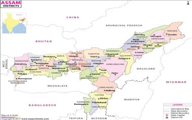
The Director of Land Records & Surveys etc., Assam is one of the oldest Directorate of Assam established in 1887. However, the office of the Assam Surveys came into existence in the year 1915. The duties and responsibilities of Assam Surveys were performed by the Assam Traverse Party & Drawing which performed its work under supervision of the Superintendent of Survey of India, thereafter Director of Eastern Circle, Survey of India and now Director of Surveys, Assam. In 1932-33, Assam Survey was separated and placed under the Director of Land Records, Assam. Since then the Director of Land Records & Surveys etc., Assam has been functioning as the Director of Surveys, Assam as well. There is 1(one) Joint Director of Surveys, 4(four) posts of Asstt. Director of Survey and also 1 (one) Asstt. Director of Survey (Printing) to assist the Director matters. This Directorate is now looking after periodical survey of land viz. Settlement/Re-settlement operation, survey of NC land, Char Survey, Printing and vandyking of maps, supply of printed maps and forms. This Directorate is also the custodian of all cadastral maps of the State and responsible for mapping and production of Administrative maps and survey of Forest boundaries and revenue area within the State. This Directorate is primarily responsible for preservation and maintenance of survey, demarcation and construction of International Boundary Pillar and also for maintenance of Interstate boundary, Inter district boundary and finally for the cadastral survey of all NC Villages of the State and also deals with land records & surveys. Assam shares Interstate boundary with West Bengal, Arunachal Pradesh, Meghalaya, Tripura, Nagaland, Manipur and Mizoram. The length of boundary of Assam with its neighboring state is as follows: Assam- West Bengal : 127.00 KM Assam- Arunachal Pradesh : 804.10 KM Assam- Meghalaya : 884.90 KM Assam- Tripura : 46.30 KM Assam- Nagaland : 512.10 KM Assam- Manipur : 204.10 KM Assam-Mizoram : 164.60 KM Assam also shares International Boundary Bhutan and Bangladesh. The India (Asasm)-Bhutan Boundary stretches to a total of 265.8 KM falling within 4 (four) sector namely,
India (Assam) - Bangladesh Boundary at a Glance |
||||||||
| Name of Sector | length in KMs | No. of Strip Maps | No. of BPs erected | |||||
| Main | S-Pillar | T shaped Pillar | R- Pillar | Total | Remarks | |||
| Dhubri-Kurigram Sector | 134 | 51 | 70 | 530 | 1743 | 41 | 2384 | MP1001 to MP1071 |
| Cachar-Sylhet Sector | 33.6 | 13 | 19 | 172 | 113 | 76 | 380 | MP1338 to MP1356 |
| Karimganj-Moulavibazar Sector | 95.4 | 29 | 41 | 313 | 241 | 49 | 644 | MP1357 to MP1800 |
| 263 | 93 | 130 | 1015 | 2097 | 166 | 3408 | ||
Status of Pillar construction in AP (Adverse Possession) and Undemarcated International Boundary of India-Bangladesh during 2015-16 |
|||||||
| Sl. No. | Sector's Name | Pillar constructed | Main Pillar | Subsidiary Pillar (SP) | Tertiary Pillar (TP) | Reference Pillar (RP) | TOTAL |
| 1 | Dhubri-Kurigram (Adverse Possession) MP1067 to 1067/15-T Strip Map No. 49 | Assam Share | - | 2 | 7 | - | 9 |
| 2 | Bangladesh Share | 1 | 2 | 8 | - | 11 | |
| 3 | Madanpur-Palathal (Adverse Possession) 1370/4-S to 1373/1-S Strip Map No. 225 & 225/1 | Assam Share | 1 | 27 | - | - | 28 |
| 4 | Bangladesh Share | 1 | 26 | 0 | - | 27 | |
| 5 | Lathitila-Dumabari (Undemarcated dispute) 1397/1-S to 1400/J-RB Strip Map No. 229 & 230 | Assam Share | 1 | 7 | - | 5 | 13 |
| 6 | Bangladesh Share | 1 | 8 | - | 5 | 14 | |
